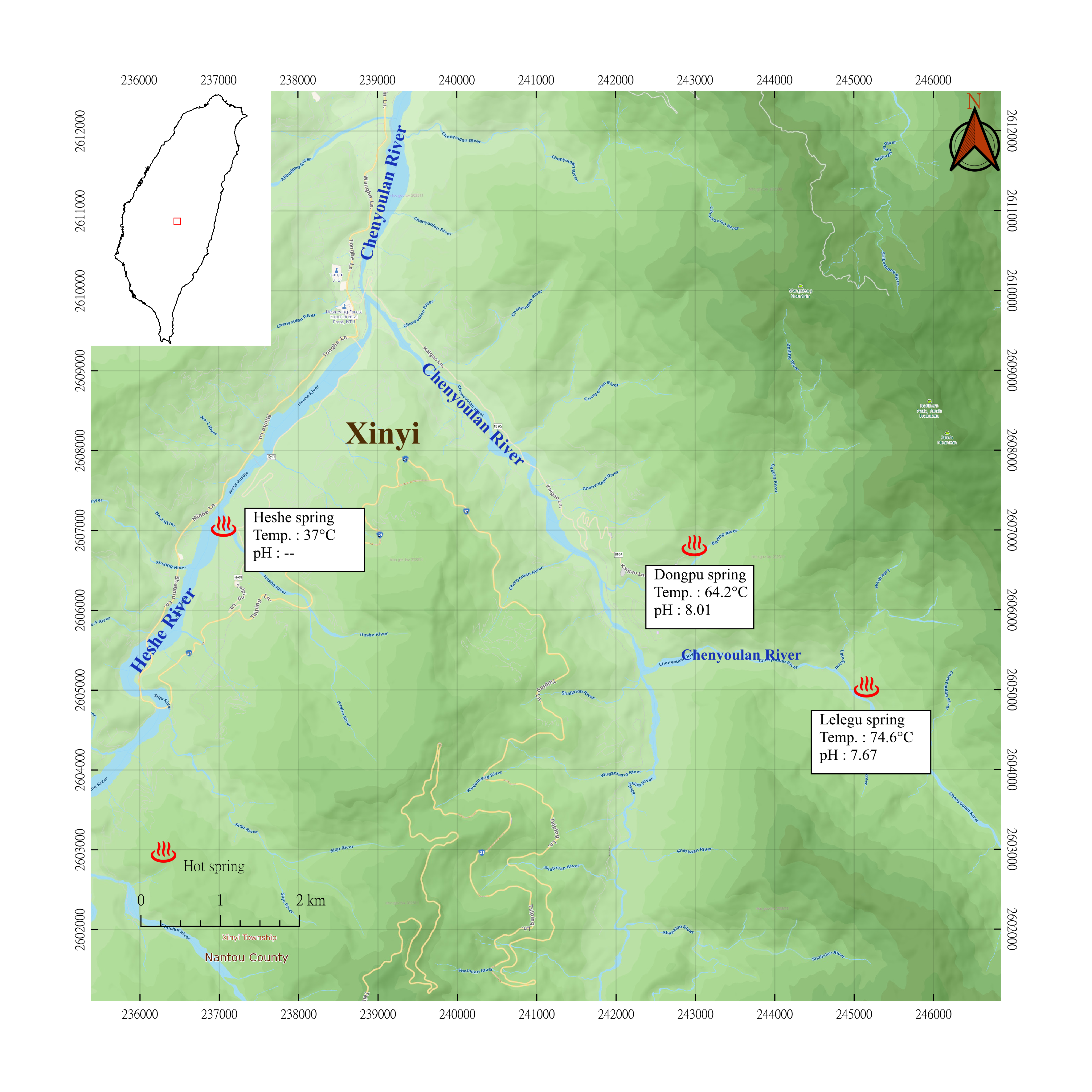
Regional Overview of Dongpu
Dongpu, located in the central Taiwan, a geothermal potential field in the slate belt of the Hsuehshan Range. The geothermal information is not well explored, with early surveys lacking comprehensive data. This project employed geological surveys, geophysical exploration, and geochemical analysis to construct a three-dimensional geothermal model. The model suggests a high geothermal gradient due to plate compression uplifting hot rocks and creating a fracture system facilitating hydrothermal flow. Thermal waters, characterized as bicarbonate type with temperatures ranging from 123°C and 177°C, seem to ascend through fractures, with some emerging as hot springs. A preliminary model points to a heat source east of Dongpu and Lele springs, potentially influenced by cooling meteoric water, with a suspected deep geothermal structure to the south that warrants further exploration.
Geological Survey
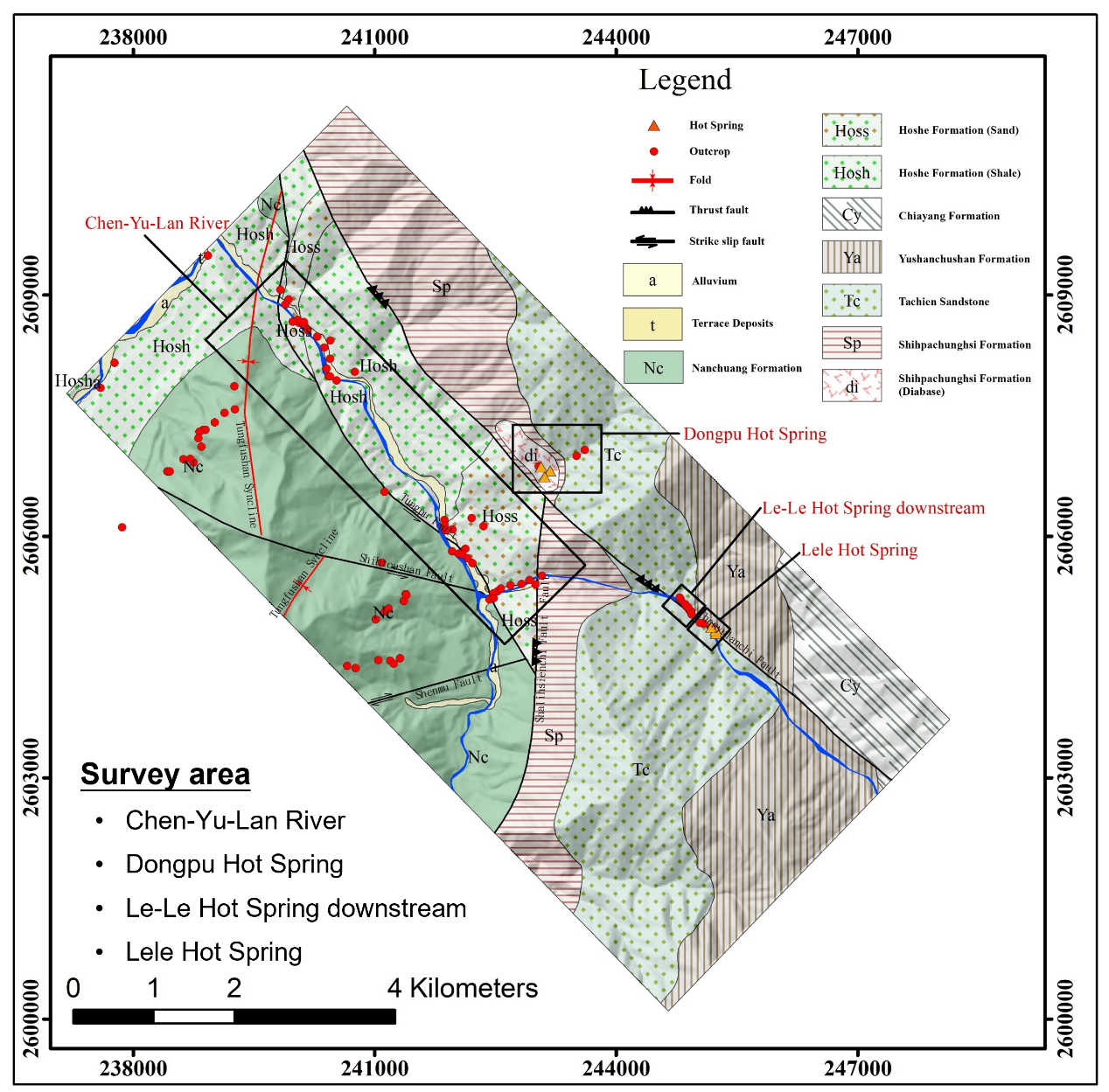
The Dongpu geothermal area underwent a comprehensive geological survey, which included: (1) surface lineament and reactivation analysis; (2) outcrop fracture measurement and paleostress inversion; (3) fracture parameter measurement and Discrete Fracture Network (DFN) analysis; (4) geothermal geological survey.
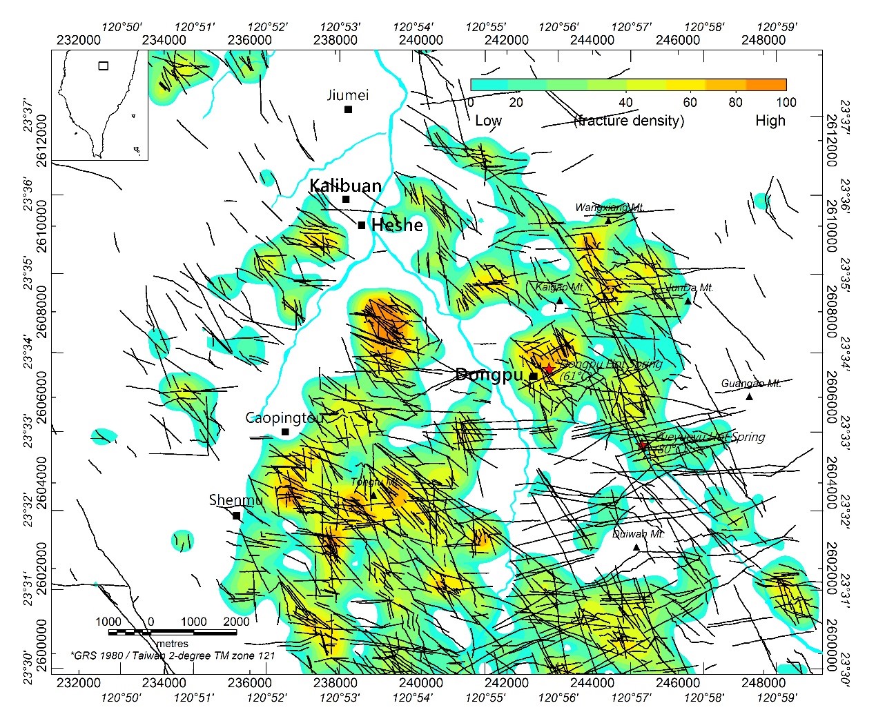
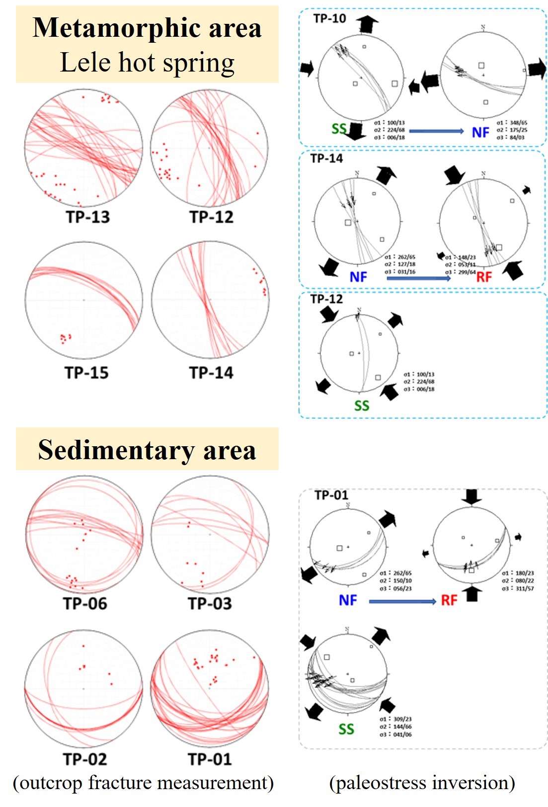
Utilizing a high-precision Digital Elevation Model, we identified 2,820 high-reliable lineaments with high-angle fractures and diverse strikes. In the in-situ stress field, potential fracture reactivation trends NW and W-E, while metamorphic area outcrop fractures align NW-SE, possibly due to oblique plate collision. Paleostress inversion revealed NW-SE orientation for outcrop-scale joints. Using Scan-Window Sampling, we measured fracture parameters and generated DFN realizations for analyzing conductive fractures and their correlation with thermal fluid pathways. Geothermal outcrop observations indicated multiple joint intersections on the fault hanging wall fracturing sandstone layers, forming effective thermal water reservoirs. The thick fault gouge in Shuilikeng Fault acts as a thermal barrier structure.

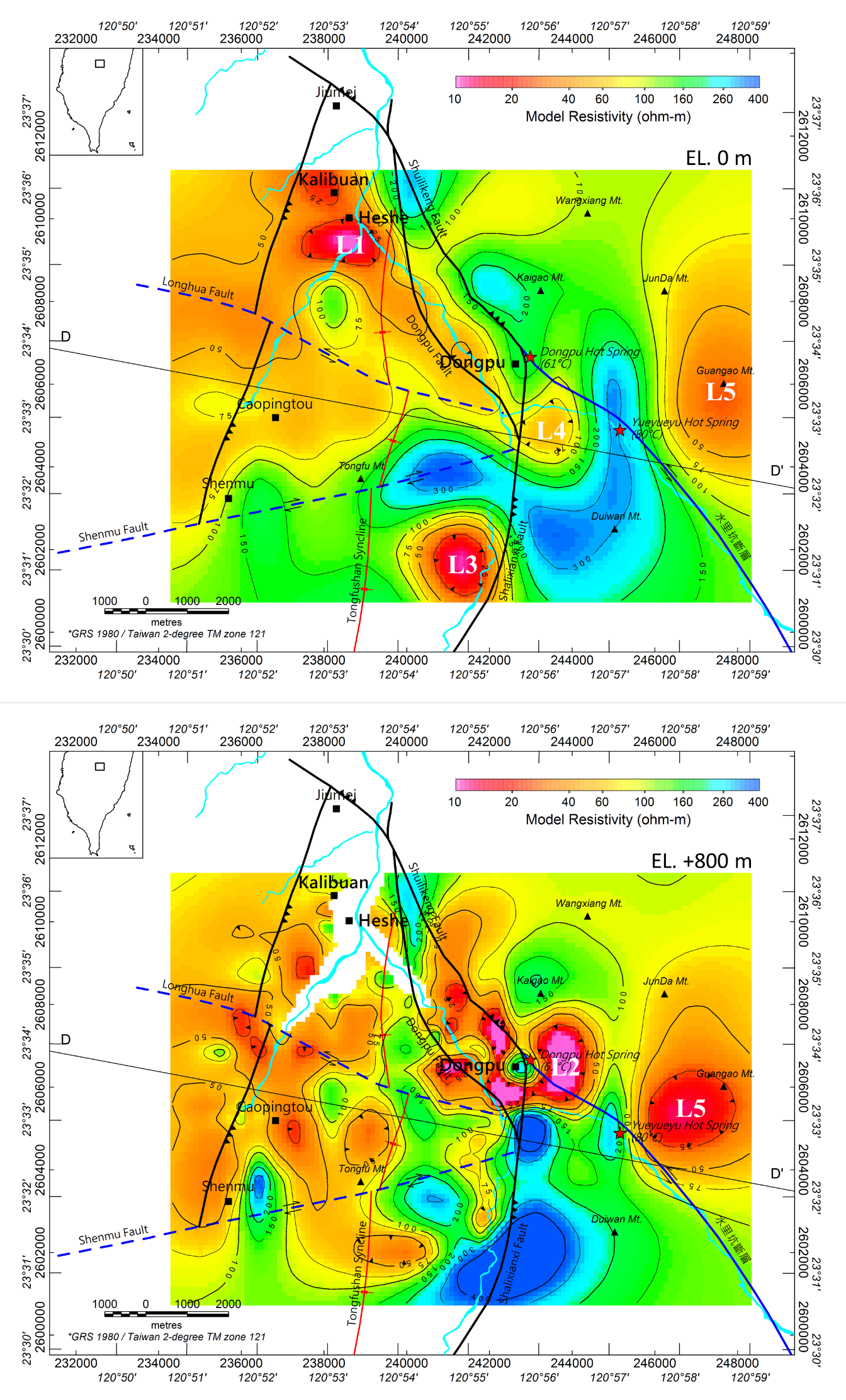
Geophysical Survey
The Magneto-Telluric survey (MT) measures orthogonal electric and magnetic fields on the Earth's surface. By converting time-series records into impedance tensors and utilizing inversion processing, underground electrical resistance models are obtained.
The high-temperature, high-salinity geothermal water stored in fractured rock formations significantly reduces the resistivity of the rock by ten to a hundred times. Therefore, the low resistance distribution characteristics can be regards as geothermal features such as clay cap layers or fractured zones with high-temperature thermal waters. In the project, a high-resolution 3D resistivity model with a horizontal grid of 112.5 meters was generated using nested inversion techniques. According to the low resistance distribution characteristics, five potential geothermal structures are explained. The L5 low anomaly is located below the Guangao Mountain, where hot water outflows and becomes famous hot springs in the area. The L3 suspected blind geothermal structure is located in the south of the survey area, with hot water rising from a depth of 7 km.

Geochemical Survey
A geochemical survey was conducted to analyze thermal water and gas samples, aiming to comprehend the characteristics and sources of geothermal fluids. Lele hot spring exhibits higher temperature, conductivity, and total dissolved solids compared to Dongpu hot spring. The chemical composition reveals a NaHCO3 type geothermal water with a neutral to weak alkalinity. Isotopic analysis (δD and δ18O) suggests the geothermal water is recharged from high mountain water. A three-component mixing model was employed to determine helium source and component contribution, indicating the geothermal fluid is derived 80-97% from crustal components with a slight atmospheric contribution. Deep circulation heats the thermal water, with an estimated geothermal reservoir temperature of 123°C using the Na-K-Ca geothermal thermometer. This comprehensive analysis enhances our understanding of geothermal fluid characteristics and sources.
Note: GMWL: global meteoric water line (Craig et al., 1961); LMWL_PLS: local meteoric water line of Puli in summer; LMWL_PLW: local meteoric water line of Puli in winter; LMWL_ALSS: local meteoric water line of Alishan in summer; LMWL_ALSW; local meteoric water line of Alishan in winter (Peng et al., 2010).
Note: Data source: BOE, 2017; Chen et al., 2020; CGS, 2020; CGS, 2021; Song et al., 2012; Yang et al., 2003; Yang et al., 2005 and this study.


Geothermal Conceptual model
Utilizing comprehensive geological, geophysical, and geochemical data, this project has initially developed a three-dimensional geothermal conceptual model for the Dongpu geothermal area. The model indicates that the high-temperature rock mass uplifted due to plate compression acts as the primary heat source for the geothermal system. Plate tectonic-induced stress has led to the formation of fracture systems, primarily extending in the northeast, northwest, and east-west directions. Thermal waters, potentially ranging from 123°C to 177°C, result from deep circulation heating by the elevated rock mass or partly from deep crustal heat. These thermal waters ascend along fractures, manifesting as hot springs upon reaching the surface. Analyzing low resistivity anomalies suggests that Dongpu and Lele hot springs may originate from the geothermal structure on the eastern side of the Shuilikeng fault. The interpreted geothermal structure in the southern study area exhibits low resistivity anomalies reaching a depth of approximately -7 kilometers. The upwelling thermal water may migrate westward and northeastward, potentially serving as a heat source for the Hoshe area.


Discussion
According to geological survey, it indicates that there are many fractures in the northwest, northeast, east-west, and north-south directions. The fractured rock formations on either side of the fault may serve as spaces for storing geothermal fluid, while the thick fault gouge acts as a hydrological barrier. Combined with fracture measurements and the paleo-stress and in-situ stress analysis, it reveals that the principal extension axis is oriented in the northeast-southwest direction. Under the influence of in-situ stress, fractures oriented in the northwest and near east-west directions exhibit a higher potential for reactivation. Geochemical survey suggest that the thermal water is heated through deep circulation of underground water and the temperature of the geothermal reservoir is estimated as 123°C based on the Na-K-Ca geothermal thermometer. Based on the spatial distribution of low-resistivity anomalies, it is inferred that there are two significant potential geothermal structures within the study area. One is located on the eastern side of the Shuilikeng fault, and the other is situated in the southern part of the study area.